A look at the Fort McMurrary by the numbers
It’s impossible to be a chemical engineering graduate without:
- having worked in Fort McMurray
- having thought about working in Fort McMurray
- having known someone who worked in Fort McMurray
I’ve had classmates work in Fort McMurray, and they have either hated it or loved it. In Spring 2008, I had an offer to work with Syncrude for my last work term, but I turned it down to try other things. The following academic term, I decided to do one of my geography assignments on Fort McMurray to get to know the place a little more, to see what I missed out. Here’s a snippet of some interesting maps and figures I compiled about Fort McMurray.
Background
Fort McMurray is located in Northern Alberta, on top of the largest oil sand deposits in the world – the Athabasca Oil Sands. Fort McMurray is the seat for the Regional Municipality of Wood Buffalo, which spans an area of 125 km3 from the North West Territories to the Saskatchewan border, making it the largest regional municipality in Canada by area [7]. The average winter temperature is -16C, 16C in the summer [4].
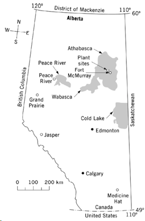
Europeans first reached Fort McMurray in the late 1700’s to setup trading posts. Naturally, these explorers were intrigued by the vast oil sand deposits in the region, which the native populations had historically used to waterproof their canoes.
Various government and academic organizations researched applications for the oil sands from the late 1800’s well into the mid 20th Century [10]. However, industrial scale development of the oil sands did not begin until the 1960’s, when Great Canadian Oil Sands, later acquired by Suncor Energy, pioneered the world’s first viable oil sands operations [9]. With a rise in geopolitical events, such as the Arab Oil Embargo in 1973, it became more feasible to expand the oil sands and thus the multi-company venture Syncrude led the second phase of development in the oil sands [10]. Fort McMurray saw its population grow from 6000 in 1971 to 27 500 in 1979 [1].
Population
Fort McMurray is a classic boomtown – industry is dominated by one industry and population growth is sensitive to external economic factors like the price of oil. It’s population began growing rapidly with the construction and commissioning of Suncor and Syncrude’s oil sands operations. World oil prices crashed in the mid 1980’s which lead to a period of stagnation. Fort McMurray began growing again with the recent surge in global commodity prices.

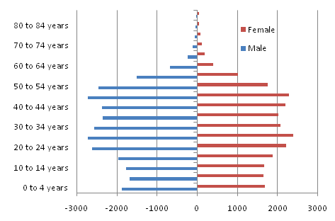
Age-Sex Structure
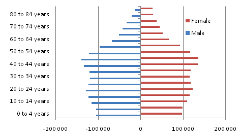
Fort McMurray’s age-sex structure implies that it’s population is in decline, where Alberta has a stable population. Fort McMurray’s lack of a young population requires it to rely on migrants.
Notable differences between Fort McMurray and Alberta’s age-sex structure include:
- Males largely outnumber females in each age group, especially working ages
- Lack of children relative to Alberta population curve
- Lack of seniors
Fort McMurray Population Curve
Alberta Population Curve
Population Source
When Suncor had established its oil sands operations and Syncrude was constructing its plant in the mid 1970’s, 41% incoming migrants claimed to be from Alberta. The next major sources were from Central Canada and Western Canada with 19% and 16% respectively.
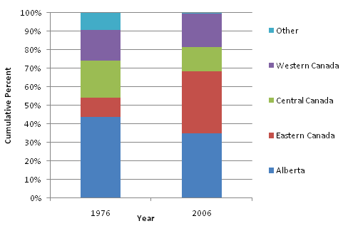
In 2006, the composition of migrants changed drastically. Alberta was still the dominant source of migrants with 32%, but Eastern Canada became the next major source of migrants to Fort McMurray with 31%. In the early 1990’s Newfoundland saw its cod fish industry collapse due to unsustainable fishing practises in the Grand Banks, which led to high unemployment and a reputation of a have-not province. With the emergence of Phase III oil sands project, there was a need for human capital, which created mass migration of Newfoundlanders to Fort McMurray. Given that Fort McMurray has fairly inhospitable climate, many Newfoundlanders find work in Fort McMurray on a seasonal basis.
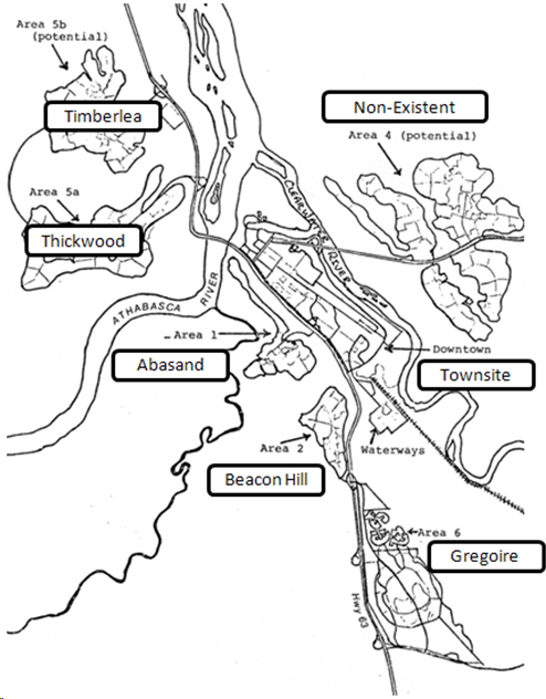
Settlement Structure
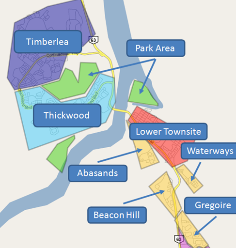
The town of Fort McMurray can be broken in two areas relative to the Athabasca River. The portion southeast of the Athabasca River, colloquially known as “the Hill”, is predominately the older part of the town; the region north of the river is the newer residential area geared towards the middle and higher class residential housing. Mobile homes and apartments have become more prominent in the cultural landscape of Fort McMurray with the development of the oil sands [3]. An example of one of these intensive residential communities is Gregoire, which had up to 88% mobile homes of the total number of housing units in 2002.
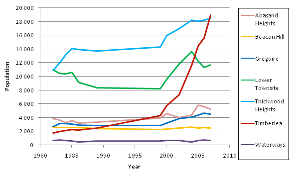
The population growth of each community over a 25 year period can be seen below. The most rapid growth has occurred in the residential communities of Timberlea and Thickwood. This had led to new business and commercial areas lying outside of the Lower Townsite, to support the local subdivisions.
Waterways
Waterways is the site of a separate community that existed prior the modern-day Fort McMurray, which incorporated as a village with Fort Mac in 1947 [6]. It has some of the oldest housing in the town, and is largely composed of single detached houses [7].
Lower Townsite
The Central Business District, or CBD, in Fort McMurray is loosely defined as the Lower Townsite. The local government is located in the CBD, big box stores, small businesses, and the regional offices for oil sands companies. The CBD also contains intensive lower class residential housing in the form of apartments. In 1961 only townhouses and single detached homes were present in the CBD, but by 1999 67% of all housing units in the Lower Townsite were apartments [3], [7].
Thickwood
The Thickwood neighbourhood was the largest subdivision in Fort McMurray from the early 1980’s until Timberlea surpassed it in 2007 [7]. Thickwood Heights is considered the more established family community in Fort McMurray. Single detached homes make up more than 60% of the type of housing units in this area.
Timberlea
Timberlea was created in 1986 as a separate subdivision from Thickwood [7]. As seen in Figure 11, it has experienced the largest growth rate in the third phase of oil sand projects and in 2006 surpassed Thickwood as the largest subdivision by population. Timberlea has seen the most growth in Fort McMurray, and commercial sites have begun to spring into the area. Single detached homes make up more than 60% of the type of housing units in this area.
Abasands, Beacon Hill and Gregoire
Abasands, Beacon Hill and Gregoire were all communities built to house construction workers from Phase I and II of the oil sands. These communities have seen the lowest growth in Fort McMurray during Phase III of the oil sands expansion. Townhouses are the major housing unit in Abasands with 58% , while Gregoire is dominated by mobile units with 88%.
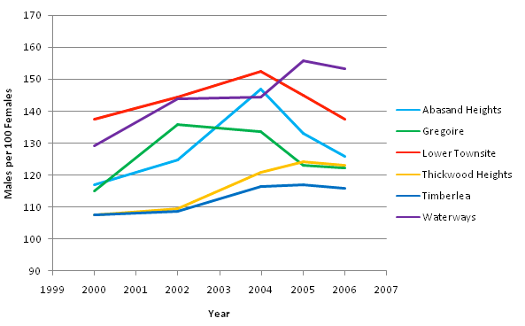
Male-female ratio in Fort McMurray
One of the most obvious differences between Fort McMurray population and Canada is the ratio of men to women. The ratio ranges from 110 to 140 for most of the working age in Fort McMurray compared to 99-104 in Alberta. The ratio of males to females in each Fort McMurray subdivision is shown below. The number of males out number females in every community, but the ratio generally decreases as distance increases from the CBD into more middle to higher class residential areas. The large number of single men in the downtown core is believed to be the cause of the high crime rates in Fort McMurray, along with more intensive residential units [11].
Housing Type
Before the establishment of oil sands operations, only single detached houses and townhouses were present in Fort McMurray. When Suncor and Syncrude began operating in the oil sands there was a sharp increase in mobile homes, especially during construction phase.

Oil Sands Operations

Suncor’s Phase I operations are the closest site to the town of Fort McMurray, followed by Syncrude’s Phase II operations. During Phase III, the extent of the oil sands has greatly expanded as well as the number of companies operating in the region. Open pit mines are common for the oil extraction, but over time steam is used to extract oil where open pit mining becomes uneconomical.
Conclusions
Fort McMurray had traditionally been a remote trading village in Northern Alberta, until the development of oil sands operations in the late 1960’s and 1970’s. This had an influence on the population of the town, its economy, its settlement structure.
Historically, oil sands operations have always expanded when there had been sustained high oil prices. These capital projects created an influx of construction workers, who have traditionally been men. During the construction phase, men often lived in communities devoted to temporary workers like Abasands and Gregoire, which were located close to all the amenities of downtown, but in a location that had a lower economic rent. Apartment complexes also became the norm in the Lower Townsite for more intensive residential housing. Mobile homes and apartments were absent in Fort McMurray’s cultural landscape before its modern history.
When the construction phase was completed for these projects, oil sands companies required more stable employees, which are often more family oriented, and thus middle and higher class residential areas formed to house mostly employees of oil sands companies in Thickwood and Timberlea. Oil sands companies have always offered housing subsidies to offset the high cost of living that is experienced in Fort McMurray, as is the case with any boomtown. This led to a gradient in the settlement structure in which these well paid workers lived in single detached homes north of the river, whereas lower paid workers in other sectors settled on the Hill [1]. Another metric that demonstrates the gradient across the river is the ratio of men to women increasing as distance to the CBD decreases.
Finally, billion dollar oil sand extraction projects have drastically changed the landscape of Fort MacKay, which is where most of the oil sands operations are located north of Fort McMurray. Open pit mines have made the natural landscape largely absent, and the chemical plants required to refine the bitumen have made sites industrialized.
In conclusion, the oil industry has been the foremost driving force in Fort McMurray’s population, settlement structure, and economic activity.
References
[1] Alberta Department of Municipal Affairs. (1977). Comparitive employment report – Fort McMurray – A Study of Future Employment Patterns in Fort McMurray, Alberta. Edmonton: Fort McMurray Planning Team.
[2] Alberta Oil Sands Environmental Research Program. (1978). Community Studies: Fort McMurray, Anzac, Fort MacKay. Edmonton: Alberta Oil Sands Environmental Research Program.
[3] Alberta Oil Sands Environmental Research Program. (1980). Study of Human Adjustment in Fort McMurray – Vol I: Field Study and Results. Edmonton: Alberta Oil Sands Environmental Research Program.
[4] Environment Canada. (2009, March 22). National Climate Data and Archive. Retrived from http://www.climate.weatheroffice.ec.gc.ca/climate_normals/index_e.html
[5] Kudelik, Gail. Wood Buffalo. In The Canadian Encyclopedia. Retrived March 24, 2009 from http://www.thecanadianencyclopedia.com
[6] Pannekoek, Fritis. Fort McMurray. In The Canadian Encyclopedia. Retrived March 24, 2009 from http://www.thecanadianencyclopedia.com
[7] Regional Municipality of Wood Buffalo. (2009, March 20). Municipal Census – Demographics – RMWB. Retrieved from http://www.woodbuffalo.ab.ca/business/demographics/demographics.asp
[8] Statistics Canada. (2009, March 20). Community Profiles – Wood Buffalo. Retrieved from http://www.statcan.gc.ca/
[9] Suncor Energy Inc. (2009, March 23). The Oil Sands History (1960s, 1970s, 1980s). Retrieved from http://www.suncor.com/popup.aspx?cid=332
[10] Syncrude Canada. (2009, March 23). Oil Sands History. Retrieved from http://www.syncrude.ca/users/folder.asp?FolderID=5657
[11] CBC. (2009, March 25). Green light for Fort McMurray work camps. Retrieved from: http://www.cbc.ca/canada/story/2006/03/15/work-camps-fort-mcmurray060315.html


Leave your response!